Started riding at the Neville Island ice skating rink, because that's where I needed to be at the end of my liberty to pick my daughter up. Rode toward the city on Neville Island, and a southeast ride almost always has a tailwind around here but today the wind was quite strong out of the southeast, so I did the work going out and had the benefit coming home.
Much the same route as yesterday, Neville Island to the mainland, McKees Rocks, Route 51 to Station Square and the trails complex, to South Side. At South Side I stopped at REI because I have a REI cash card for $20 that expires in two weeks. I purchased a pack of hand- and feet-warmers, and some chocolate-sesame snack bars.
I was very pleased to encounter Sara outside REI, "just" bicycling over from Oakland to do some shopping. That's very proto-nu-Pittsburgh, she's a very nice lady and sort of a live demo of what could be in a Pittsburgh 3.0 that embraces 2.0 wheels.
Continued down to Keystone Metals. Saw lots of activities and some very big men at the Steelers training facility. There was a satellite downlink truck and a reporter doing what reporters do while trying to stay mostly out of the rain.
No sign of much progress on the Keystone Metals portion of the trail. Got all blinkied up for the return leg and turned north. I was only a little wet over most of the body, but my socks and shoes were soaked.
With the tailwind behind me I got back to the car much earlier than I expected, so I continued further to Stoops Ferry and then rode back to the ice hockey rink. 38 miles, a very nice ride. I could have used a few towels to dry off after the ride.

 (explanation: "on the rivet" Covering the Tour de France, Paul Sherwin used the phrase "on the rivet" to describe one of the guys struggling mightily in the Pyrennees today...
  238#
238# less seriously, because it provides an excellent demo of the new backpack airbags skiers carry for avalanches, and as I pedal around Point State Park to the Convention Center I've been thinking about getting a pair.


 Some may have read the article today in the PG on women in Pittsburgh's labor force. It references a report we did some years ago on gender wage differences in the Pittsburgh region. Note the story today does not mention the third author Susan Hansen as well for the record. No matter how you parse it, I have been saying for some time (page 3 of this* for example) that the trend in female labor force participation is one of the keys to understanding economic transformation in Pittsburgh.
 4th grade.
 My Wedding 20 years later
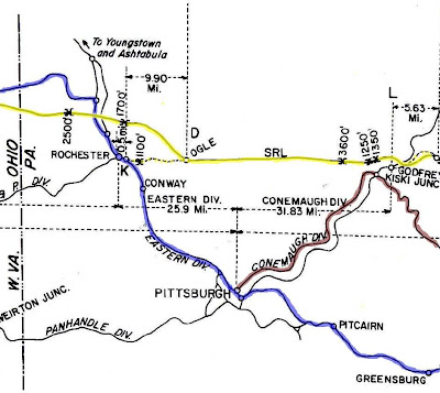 The yellow line represents the proposed Samuel Rea Line noted as SRL. The PRR mainline is shown in blue. The Conemaugh line from the Northside of Pittsburgh to Bolivar, Pennsylvania is shown in dark red / brown. Northwest of Pittsburgh, near Rochester, Pennsylvania a dotted line shows a new connection from the mainline to a place called Ogle for a connection with the Samuel Rea Line. Northeast of Pittsburgh near Kiski Junction across the Allegheny River from Freeport a dotted line shows where a proposed connection with the Connemaugh Division would have been made at a place called Godfrey, Pennsylvania. All tunnel locations have their length in feet indicated.
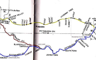 The Samuel Rea Line is shown in yellow. The Allegheny summit would have been attained to the west of a large 14,750 foot tunnel that would have been built between Alburn and St. Lawrence, Pennsylvania. The mainline is in blue. The Conemaugh division is in dark red / brown.
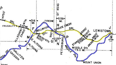 The west portal of the 5.57 mile tunnel proposed for the Samuel Rea Line in yellow would have been near Frugality, Pennsylvania. Connection with the PRR mainline would have been made at the west portal of the 9200 foot tunnel through Brush mountain between Tyrone to the north and Altoona to the south. Other connections to the PRR mainline would have been made in the vicinity of Spruce Creek, Pennsylvania.

